Santa Rosa County Card Print 27-2N-28-0550-00A00-0210
The Santa Rosa County Property Appraiser and staff are constantly working to provide and publish the most current and accurate information possible. No warranties, expressed or implied are provided for the data herein, its use, or its interpretation. The current assessed values as viewed herein are 2026 Certified values.
PHILLIPS DALE E & MARY L6939 CEDAR RIDGE CIRMILTON, FL 32570-3664
27-2N-28-0550-00A00-0210 Printed: 11/18/2026 2:3Appr: 12/08/2024 SPPA
Santa Rosa CountyReal Property 2026Card: 001 of 001By: Website
| BUILDING USE | SINGLE FAMILY (000100) |
| modl | SFR (1) | Bath | 2 |
| extw | BRICK (20) | Fixt | 0 |
| 0% | | BED | 3 |
| RSTR | HIGH PITCH (04) | ROOM | 0 |
| RCVR | TIMBERLINE SHINGLE (06) | UNTS | 0 |
| 0% | | C-W% | 0 |
| INTW | DRYWALL (05) | hght | 8 |
| 0% | | pmtr | 0 |
| flor | CARPET (14) | stys | 1 |
| 0% | | econ | 0 |
| heat | FORCED AIR DUCT (04) | func | 0 |
| airc | CENTRAL (03) | spcd | 0 |
| qual | CLASS 4 (04) | depr | 20 |
| fndn | MONOLITHIC (02) | ENGY | FULL (03) |
| SIZE | | MARA | MKT AREA 7 (07) |
| ceil | | CONR | 10 CORNERS (10) |
| ARCH | | FIRE | |
| frme | WOOD FRAME (02) | ELEV | |
| ktch | AVERAGE (01) | UD-8 | |
| clas | ZONE I (02) | occ | |
| code | actual | heated | effect | rcnld |
|---|
| Total | 0 | 0 | 0 | $0 |
| Field Check: | 02/15/2010 RB |
| Situs: | 6939 CEDAR RIDGE CIR, MILTON, 32570 |
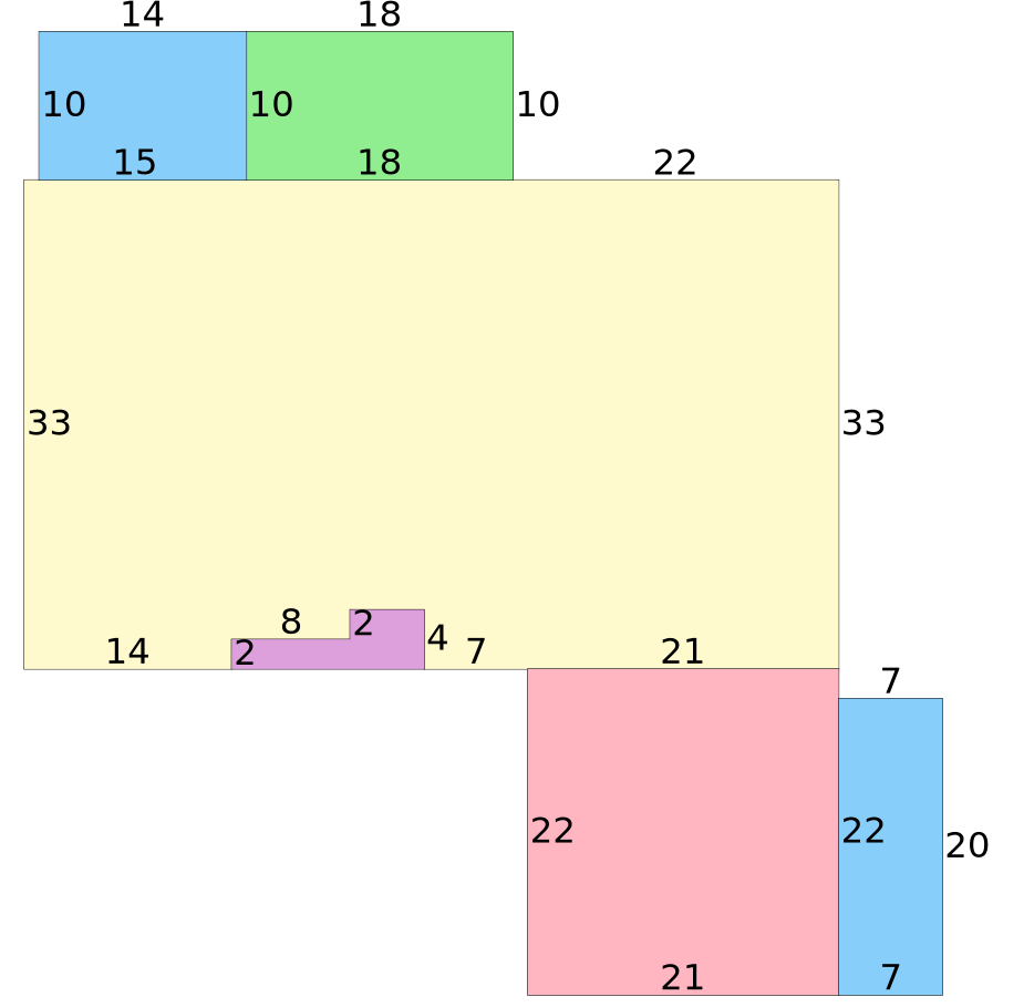
Building Traverse
BAS1997=W22OP12016=N10W18S10E18$W18PTO1997=N10W14S10E14$W15S33E14N2E8N2E5S4FOP1997=W13N2E8N2E5S4$E7FGR1997=E21S22PTO2007=E7N20W7S20$W21N22$E21N33$.
| Bldg Val | $167,205 |
| RCN | $209,007 |
| PARCEL USE | SINGLE FAMILY (000100) |
| AYB | 1997 |
| EYB | 1997 |
| STR | 27-2N-28 |
| Acres | 0.233 |
| MARA | MILTON/SKYLINE |
| (07) |
| SUBD | CEDAR RIDGE |
| (00550) |
| Block | 00A00 |
| Lot | 0210 |
| EXPTS | HX SX |
| Txdt | MILTON |
| (3) |
| |
| |
| BLDG | $167,205 |
| XFOB | $1 |
| LAND | $26,000 |
| CLAS | $0 |
| MKTUSE | $0 |
| JUST | $193,206 |
| APPR | $193,206 |
| NEWC | $0 |
| SOHD | $68,099 |
| NSASSD | $125,107 |
| SCASSD | $125,107 |
| EXPT | $101,411 |
| COTXBL | $23,696 |
| CITXBL | $23,696 |
| OTTXBL | $73,696 |
Permits
Sales
| Book | Page | Date | Q/U | V/I | Price |
| 2912 | 42 | 06/26/2009 | Q | I | $125,000 |
| Grantor: | HILL RON G & MARY JO |
| Grantee: | PHILLIPS DALE E & MARY L |
| 2621 | 1804 | 06/05/2006 | Q | I | $162,500 |
| Grantor: | MARCOTTE LYNETTE MARIE |
| Grantee: | HILL RON G & MARY JO |
| ... 4 more |
Extra Features
| Code | Description | Length | Width | Height | Quantity | Qual Code | Year | Unit Count | Unit Type | Unit Price | SPCD | % | Value |
|---|
| SHED | SHED | 0 | 0 | 0 | 1 | | 2002 | 1 | UT | $1.00 | | 0.00 | $1 |
Land
| Code | Description | Front | Back | Depth | Depth Code | Units | Unit Type | Unit Price | Value |
|---|
| 000100 | SINGLE FAMILY | 70 | 0 | 145 | | 1 | LT | $26,000.00 | $26,000 |