Santa Rosa County Card Print 34-2N-28-5620-00300-0030
The Santa Rosa County Property Appraiser and staff are constantly working to provide and publish the most current and accurate information possible. No warranties, expressed or implied are provided for the data herein, its use, or its interpretation. The current assessed values as viewed herein are 2026 Certified values.
MCDONALD DEREL H &MCDONALD RACHEL E5342 MUNSON HWYMILTON, FL 32570-4490
34-2N-28-5620-00300-0030 Printed: 11/12/2026 19:23Appr: 07/08/2025 SPIM
Santa Rosa CountyReal Property 2026Card: 001 of 001By: Website
| BUILDING USE | SINGLE FAMILY (000100) |
| modl | SFR (1) | Bath | 2 |
| extw | BRICK (20) | Fixt | 8 |
| 10% | STONE (21) | BED | 3 |
| RSTR | COMBO EXTREME (15) | ROOM | 0 |
| RCVR | TIMBERLINE SHINGLE (06) | UNTS | 0 |
| 0% | | C-W% | 0 |
| INTW | DECORATIVE (07) | hght | 9 |
| 0% | | pmtr | 0 |
| flor | CLAY/CERAMIC TILE (11) | stys | 1 |
| 70% | CARPET (14) | econ | 0 |
| heat | FORCED AIR DUCT (04) | func | 0 |
| airc | CENTRAL (03) | spcd | 0 |
| qual | CLASS 5 (05) | depr | 15.85 |
| fndn | BLOCK/MASONRY (03) | ENGY | FULL (03) |
| SIZE | | MARA | MKT AREA 7 (07) |
| ceil | | CONR | 10 CORNERS (10) |
| ARCH | | FIRE | |
| frme | WOOD FRAME (02) | ELEV | 20 FEET (20) |
| ktch | AVERAGE (01) | UD-8 | |
| clas | ZONE I (02) | occ | |
| code | actual | heated | effect | rcnld |
|---|
| Total | 0 | 0 | 0 | $0 |
| Field Check: | 01/30/2018 CJ |
| Situs: | 5342 MUNSON HWY, MILTON, 32570 |
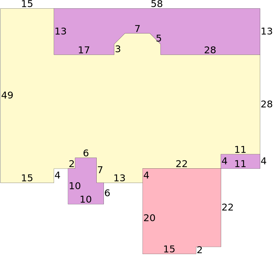
Building Traverse
FOP2004=W58S13E17N3/N3E3/E7/S3E3/S3E28BAS2004=W28N3/N3W3/W7/S3W3/S3W17N13W15S49E15N4E4FOP2004=E2N3E6S7E2S6W10N10$E2N3E6S7E13FGR2004=S20E15N2E7N22W22S4$N4E22FOP2004=N4E11S4W11$N4E11N28$N13$.
| Bldg Val | $284,554 |
| RCN | $338,152 |
| PARCEL USE | SINGLE FAMILY (000100) |
| AYB | 2004 |
| EYB | 2004 |
| STR | 34-2N-28 |
| Acres | 0.688 |
| MARA | MILTON/SKYLINE |
| (07) |
| SUBD | WATERFRONT (ADDITION TO JAMES QUINN TRACT) |
| (05620) |
| Block | 00300 |
| Lot | 0030 |
| EXPTS | HX VX |
| Txdt | MILTON |
| (3) |
| |
| |
| BLDG | $284,554 |
| XFOB | $0 |
| LAND | $75,000 |
| CLAS | $0 |
| MKTUSE | $0 |
| JUST | $359,554 |
| APPR | $359,554 |
| NEWC | $0 |
| SOHD | $104,362 |
| NSASSD | $255,192 |
| SCASSD | $255,192 |
| EXPT | $56,411 |
| COTXBL | $198,781 |
| CITXBL | $198,781 |
| OTTXBL | $198,781 |
Permits
| Number | Desc | Amt | Issued |
| 20075247000B0 | DOCK/SEAWL | $2,000 | 12/18/2007 |
| 2300483 | DEMOLITION | $2,200 | 02/04/2003 |
| ... 1 more |
Sales
| Book | Page | Date | Q/U | V/I | Price |
| 4747 | 641 | 04/27/2026 | U | I | $100 |
| Grantor: | MCDONALD DEREL H & RACHEL E |
| Grantee: | MCDONALD DEREL H & MCDONALD RACHEL E ET AL |
| 783 | 134 | 12/01/1985 | Q | I | $58,000 |
| Grantor: | |
| Grantee: | MCDONALD DEREL H & RACHEL E |
Extra Features
| Code | Description | Length | Width | Height | Quantity | Qual Code | Year | Unit Count | Unit Type | Unit Price | SPCD | % | Value |
|---|
Land
| Code | Description | Front | Back | Depth | Depth Code | Units | Unit Type | Unit Price | Value |
|---|
| 000116 | SINGLE FAMILY - BAYOU | 100 | 0 | 300 | | 100 | FF | $750.00 | $75,000 |